——EDIT——-
August 2014
One of the very first reviews I ever wrote in the US was in 2004 on epinions, about this GPS V. I found it, and am therefore posting it here.
The Garmin GPS V deserves a 2014 mention because I’ve had quite a bit of experience with a variety of other GPS’s in the last decade and am still really stunned at the reliability of my Garmin GPS V.
The tech is very old, the automotive navigation is next to useless, and the interface to a computer to download maps is agonizingly slow and a nearly pointless 19MB (without an SD card expansion slot).
But, without question, while many high-tech GPS’s I’ve purchased have broken, or become unusable, or have had the internal (and uncheangeable) battery die, the GPS V is still working exactly as efficiently (or inefficiently, depending on how you use it) as it did the day I got it.
This GPS should not be used as an automotive navigation device.
It’s true power comes from simply always working, never failing. It will give you your GPS coordinates always, and if you have the base maps loaded, it will show you approximately where you are, and if you have the detailed topo or marine maps loaded, it will show that information as well.
As I have had quite a bit of gear fail in the field (I like backpacking and go out fairly often), I’ve come to realize that my electronic gear needs to be two things absolutely and always, to prevent failure in the field:
– Rugged
– Waterproof
Not rugged’ish….rugged. And that means seriously shock proof. i’ve dropped this GPS V going 40 mph (don’t ask, hahaha)
And not “water resistant”. Water resistant is the most meaningless con ever. Water proof…completely water proof is an absolute requirement when you’re out in the field.
I find it impressive that after all these years, while other electronic gear comes and goes, works for a while and then fails, the Garmin GPS V has stayed as consistently reliable as the day i bought it. And while I don’t take it out much anymore, since I’m now a satellite messenger and gps combo user, I will never sell my Garmin GPS V.
Because when all my other GPS gear fails, I know that this will tell me GPS location, next year, or a decade from now.
——EDIT——-
September 2009
Just used the Garmin recently for a multi-city trip and was able to install map data for key parts of Boston, Chicago, and College Town (TX) all in 19mbs. There’s not doubt that more memory would be better (say, 256 or 512), but 19 can get the job done in a pinch.
In case anyone is interested, with all the construction going on in Boston, even the latest map is pretty worthless, with lots of road errors and directiion errors. In developing Boston, they’re not only adding roads, but removing them as well. Somewhat frustrating. Luckily, College Town and Chicago were mostly unchanged since the last release and were both very accurate.
The key for Macintosh users, as mentioned earlier, is having VPC and a Keyspan serial adapter (or an IOGear serial adapter). If you install VPC, you can install the MapSource data on top of it.
There seems to be no problem with this as long as you set up COM1 in the VPC settings to be the serial port. Don’t set USB for this as it won’t work.
Which has lead to another discovery. When using USB based GPS devices (like the Garmin Quest), there seem to be numerous problems that simply don’t exist with the serial adaptor set to COM1. That’s both a relief and a disappointment. I was looking forward to the quest as my next device even though it only had 115mbs of memory (13mb for the base map comes to the expected 128mbs). Interestingly enough, in Europe they sell the 243mb version (which is 256mb minus 13mb for the base map). Either way, a major disappointment.
——EDIT——-
Based on request, here are some additional opinions regarding the GPS V. I’ve had this for a few months now and have taken it on several trips.
Let’s start with the interface.
Depending on who you ask or which review you read, the opinions of the interface range from hard to use to easy. But for me, it doesn’t seem difficult at all. A few features were a little unintuitive at first, but I assume mostly because this is my first GPS. Now, though, I have a pretty good idea of all of the key funtions. It’s easy to get to do just about anything. All the functions you would want in City/Street driving and walking are easy. The points of interest are really detailed and thhe inclusion of phone numbers is particularly useful. Of course, the only way to bring up phone numbers is to do a find. Wish they made that and the address easier to access after you made it a waypoint….
What is a little bit difficult is entering long/lat. It’s so difficult, that it’s just easier to do it with the MapSource software and then download the waypoints. I recently entered a series of waypoints from an off road trail (Used “Back Country Roads” book)
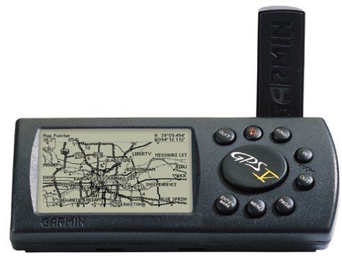
Physical buttons.
The buttons are designed to be waterproof along the edges, so the entire pad and all the buttons seem to be a single contiguous rubber piece.
The main navigation button in the center is a little “mushy” for lack of a better word. Trying to press “down” and end up pressing “right” or “left”, well, you get the idea.
Visibility of the display.
Okay, so maybe I’m new to GPS’s so my opinions are based on what I originally thought were ideal instead of in relation to other GPS’s I have used, but I think the GPS V’s screen (and every other GPS I’ve ever seen) is just too smal. You really can’t read street names.
Having said this, I like this screen’s size and resolution more than the Magellans I played around with.
The best screen on a handheld I’ve seen to date is the iQue3600. Wow, lot’s of pixels, more screen realestate, and color. But I read around that the iQue3600 breaks so easily as to be nearly worthless….
That’s the complaint, but in reality, apart from being unable to read the names without squinting and leaning in a little, I have to say that the screen is easy to see. if you guide yourself by the street lines, then there’s no problem. Especially if there’s enough variation in the street lines that you can quickly gauge where you are. In Manhattan New York….you can’t do that easily because the grid is so close to perfect in midtown. Sort of similar for San Francisco. But in Northern California’s South Bay area, it’s very easy to gauge where you are.
As to the screen’s brightness, glaring sunlight is no problem. Almost no glare or reflection (certainly not enough to complicate screen viewing). And the backlight works really well. Several months and there seems to be no fading of the backlight. The screen’s brightness controls and ability to see in daylight far surpass the iQue3600 or my Tungsten C.
Battery life.
About 20 hours contiguous on Duracell
Weight and durability.
Heavier than any Magellan. Will easily sink if dropped in water. Then again, it’s very rugged. I can see why the military uses these. I’ve dropped it several times and there has been absolutely no damage to the functionality of the device, though scrathces abound throughout. Heck, i dropped it on asphalt from a motorcycle going 40mph…went back to pick it up…and it still worked fine.
Carrying on your hip.
Not easy. instead of being flat, it’s a triangular cylinder (Like a Toblerone), with a rotating antenna on the one of the back planes. It’s really not convenient compared to other GPS’s out there.
Antenna….
okay, in a city with a bunch of skyscrapers, it’s pretty bad. you get reception, but it’s highly inaccurate. But since I set the software to always lock the GPS to a street, it’s often the wrong street.
under a canopy of trees (recently went East to some national parks), it really depends on the density of the trees. If you’re on the road and there’s Redwood branches above and trees all around, I was surprised to get decent accuracy. But if you’re hiking and walking in a dense forest where the trees are just a couple of feet away from you as you walk past them, the reception is highly inaccurate and often you lose the connection.
One thing that bothers me here is the inordinate amount of time the GPS takes to find satellites. Okay, let me re-phrase that. Sometimes it’s really fast, but sometimes it can take several minutes. The manual says that it should take several minutes only if you turn it off, and move somewhere far away….this is not accurate. because if, for instance, you move to the other side of a building, or come out from an underground garage, it can take several minutes as well.
Routing
What can I say? It’s slow as molasses. If you’ve been looking at a Roadmate, a Navman, or a Garming StreetPilot, don’t look at the GPS V. It’s ultra slow comparatively speaking. the interface is sluggish, routing and re-routing are slow, everything about it is slow.
As a side note,
WAAS
All I can say about WAAS is….wow!
it works much better than the StreetPilot if the reception is good enough. And though it takes a while to get several sattelites, once it does, it’s very accurate and definitely good enough for walking. I recently went to New Mexico and was stunned at how accurate it was while walking in Old town Albequerque and Santa Fe’s town square area.
I haven’t seen any other WAAS enabled device in action, so I can’t really comment on how it compares to other WAAS devices
What other impressions…..
Oh, I might point out here that the new Garmin Quest looks like it has all the features I wish the Garmin GPS V had. I didn’t really thinkg the 60cs, or 76cs was a replacement possibility for the GPS V….But the Quest? Yeah, I think that could be my next device.
Last complaint…..
If you use a Mac, then don’t forget to get VPC, because MapSource won’t work on the Mac, and there are no third party developers where you can use the POI database and routing functions that make the Garmin street capable.
—
Original Review: September 1st, 2004
—
This is my first GPS device.
Having read a lot of reviews (many on this epinions), I was struggling with several different models and brands of GPS to choose from. In the end, I chose on price/performance.
The Garmin GPS V, is by now (April 2004), rather dated. There are newer models from Garmin out that are better at dealing with shortcomings from the Garmin GPS V. The newer model has color, an antenna port where removing the main antenna is not required, separate power/serial/USB ports, more memory, color touch screen, and more.
But the newer models, of course, don’t come with a completely unlocked US street map. The Garmin, being discontinued, has a deluxe package that unlocks not just a particular region, but the entire United States. And the GPS V, has all the basics: WAAS, some memory (19MBs), high resolution screen, very good backlit screen, and more than anything else, is very tough.
Compared to the newer 60C/CS or 76 C/CS models, it’s missing several keys, but even these newer models don’t overcome key shortcomings in most Garmin handheld GPS’s. Key among these shortcomings is memory. the GPS V has 19MBs, the 76c/cs has 100+MBs, the latest 60C/CS has 56MBs. California alone requires more than 100MBs. What’s needed is expandable memory. Magellan GPS handhelds have SD memory card slots.
One might argue that the iQue3600 from Garmin has expandable features and a host of other really amazing features integrating PDA features and GPS features in a seemless unit. But the iQue3600 was $500 plus anywhere I looked. Someone mentioned getting one for less than $300, but I couldn’t find such good deals, even including rebates, anywhere. The iQue3600 has another key fault: durability. There were as many complaints about how easily these devices broke down as there were praises for the great integration. And wanting to take the GPS with me on all business trips, off-road travel, and local routing info when visiting new places locally, my GPS was bound to get a lot of abuse. the lack of durability turned me off completely.
Of course, everyone complains about the lack of memory, but my addendum complaints are: Screen is so small, difficult to read on dashboard, have to bring the device somewhat closer to read effectively in map mode. the the turn-by-turn is great. Secondly, there should be a Mac version of MapSource. No matter how you cut it. It’s worth it to do. No other manufacturer offers a Mac version. Sure, there are third party GPS software options, but MapSource has the detailed maps, points of interest, and routing information….it’s one thing to get a software, but without good content, too much work is required to get it to work right and you still don’t get routing. Garmin should make a Macintosh compatible version. They might be surprised at how much of a market opportunity there is. Especially if they are the only ones to do it.
Having used the Garmin GPS V for a little over a month, and having tested the iQue3600, Magellan Platinum, Magellan Sportstrac, Streetwise, and the Hertz GPS, as well as the etrex in the past 2 months, I can say that the GPS V Deluxe is the only device under $400 that I’ve seen so far with the most flexible configuration for Marine, off-road hiking/driving, on-road driving, and around town walking feautres and a full US (+ parts of Canada) street map. Though this probably doesn’t need to be said, the MapSource CitySelect CD also includes obscure off-road trails that are usually not found anywhere except on “backroads” off-road maps. Oh, and updated maps are free from Garmin.
Magellan’s bundle-packaged Platinum, Gold, and Color Meridians come very close, but no other Garmin, Magellan or Navman GPS comes close in terms of overall flexibility. The Garmin GPS V is heavier, but smaller than the Magellan handhelds (well, just thinner, so easier to pack in tight places when traveling). For hiking/off-road/and citiy driving, the Garmin GPS V is the best device for me.
